Potential activities in CoastRI align with three major categories:
- Observing coastal processes
- Cross-sector modelling and prediction
- Data identification, management, and integration
The program of work is intended to include marine, estuarine, terrestrial, subsurface, modelling and analytical elements culminating in a step-change in our understanding of coastal conditions and support risk management strategies.
CoastRI will be established via a two-stage approach.

Stage 1
Stage 1 included a number of elements which were funded in the 2023 NCRIS funding round including:
A nationwide consultation process to explore research, stakeholder, and end-user coastal data needs, impact pathways, First Nations co-design program partners, program governance and synthesis, and co-investment opportunities. The consultation is managed by IMOS, with engagement from all participating NCRIS capabilities. The consultation process is ongoing and will involve stakeholders across the entire coastal observation value chain. In addition to the analysis of end-user needs, scientific meetings will be held to explore how the identified needs can be met and how benefits can be created at regional and national scales.
A suite of initial, multi-year investments (2023-2027) to establish the initiative and demonstrate the scope and intent of CoastRI, as well as to help leverage and attract capability and co-investment. These investments include observing, data collection, data management, and modelling activities that are known gaps identified from previous consultation.
Stage 2
Stage 2 will involve implementation of CoastRI informed by user needs (defined in Stage 1) to maximise impact. Stage 2 will build on elements of Stage 1, which may include expansion of these elements if required as well as inclusion of additional activities.
CoastRI Themes
CoastRI consultation identified a range of themes to be included in the program of work for the 2025 NCRIS funding round, aimed at addressing gaps in observation, data collection, modelling, and prediction. This will involve both the collection of new data streams and the integration and aggregation of existing ones. The identified themes align well with the capacity and capability housed within the CoastRI NCRIS consortium.
While the themes identify potential derived benefits for First Nations, explicit involvement of First Nations communities will be undertaken through co-design, which is a fundamental and continuous aspect of the initiative and not restricted to any theme. Furthermore, data stewardship and sovereignty are fundamental aspects of CoastRI’s success and an underpinning component rather than a distinct theme, as depicted in Figure 1.
Proposed components of CoastRI
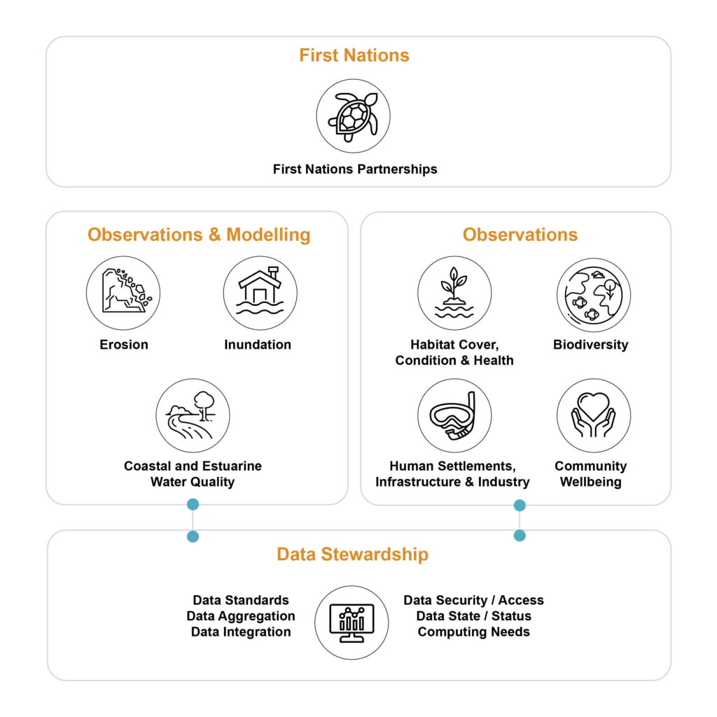
Figure 1. Depiction of the proposed components of CoastRI. Note: First Nations partnerships apply to the entire program of work rather than any element.
CoastRI submission
The CoastRI consortium has successfully completed the full program description, receiving endorsement from all 13 NCRIS partners. The description has also undergone review by an independent Science Advisory Committee and Advisory Board. It has now been provided to NCRIS for consideration as part of their step-change processes.
The timeline for a funding decision remains uncertain, but we will keep the community informed of any developments.
Next steps
If CoastRI is funded, first steps will be to organize a series of workshops including researchers, stakeholders, and Indigenous communities. These workshops will provide a platform to refine the program’s approach, identifying key activities and equipment, determining optimal deployment locations, data standards, and co-delivery and co-investment opportunities.